
Far West Texas is home to one of nature’s wonders. Established in the 1970s, the Guadalupe Mountains National Park covers over 86,000 acres on the border with New Mexico. The most famous Guadalupe Mountains National Park hike, the Guadalupe Peak trail, is known for being home to the tallest point in Texas–but hiking in Guadalupe Mountains NP goes far beyond one peak.
The size of this park means that at least one of the best hikes in Guadalupe Mountains National Park is right for everyone, no matter their skill level. The trails vary between easy, medium, and difficult and are diverse in flora and fauna, depending on starting points and the altitude.
Trails lead to high peaks, through canyons, and around the mountains’ bases. At times, the ground below your feet can be rugged with loose rocks to meander through.
We’ve gathered here the best trails to hike at Guadalupe Mountains National Park, with the information you need before taking on each one.
We have broken down the trails by their access points at each trailhead. Directions to each trailhead were added from Van Horn and El Paso, Texas.

Best Guadalupe Mountains NP Hikes From Pine Springs Trailhead
Driving Directions: From Van Horn, Tx, take Hwy. 54N for 55 miles. Then slight right onto US-180 E/US-62 E for 9 miles. Turn left onto Piney Spring Visitors Center for .1 miles, then turn right .01 miles From El Paso, TX, take US-180 E/US-62 E 95 miles. Turn left onto Piney Spring Visitors Center for .1 miles, then turn right .1 miles.
Guadalupe Peak Trail
Difficulty: Difficult
Total Distance: 9 Miles
Time to Complete: 6 to 8 hrs
Elevation Gain: 3,000 ft
The Guadalupe Peak Trail is the most popular path for serious hikers in the park. It is also the highest peak of all the mountains in Texas, making it a highly sought-after accomplishment.
With rocky outcrops and smoothly contoured valleys below, the trail has diverse scenery the higher the climb. Much of the trail is lined with small trees and large bushes where one can find a respite from the summer heat. There are sections, however, where shade is hard to find.
This trail is not for the novice. Before taking on the Guadalupe Peak, make sure to carry water for fluid intake and snacks for energy as you will expend mega calories.
Those who successfully climb to the summit are rewarded with grand views of the surrounding Chihuahuan desert and Guadalupe Mountain range.

Devil’s Hall Trail
Difficulty: Moderate
Total Distance: 4.2 miles
Time to Complete: 2.5 hrs
Elevation Gain: 550 ft.
Start your Guadalupe NP hike on this trail early to catch the sunlight bouncing off the mountains around you as it rises.
The Devil’s Hall Trail takes you through a wash, where millions of years of intermittent water flow have dug out the rock of the mountains. The layered stone tells the story of the geological history of the Guadalupe Mountains.
The further you travel on the trail, the narrower the wash becomes, hence the name, the Devil’s Hall, with its vertically steep walls on either side of the trail.
What the trail lacks in elevation gain, it makes up for it with loose boulders under your feet for much of the trip, which gives it a moderate ranking.

The Bowl
Difficulty: Difficult
Total Distance: 9.1 Miles
Time to Complete: 8-10 hrs
Elevation Gain: 2,500 ft
There may not be a better hike in Guadalupe Mountains National Park than the Bowl Trail to appreciate the Chihuahuan Desert and its plant life. The trail has plenty of shade as you hike through the dry river bed with plenty of trees for shade.
After the river bed, the climb begins to the edge of the bowl, where at times, the rocks act more like stair steps than a stone trail.
After this literal breathtaking climb, however, you are rewarded with a forest of pine and fir trees, a more moderate hike in nature, and panoramic views.

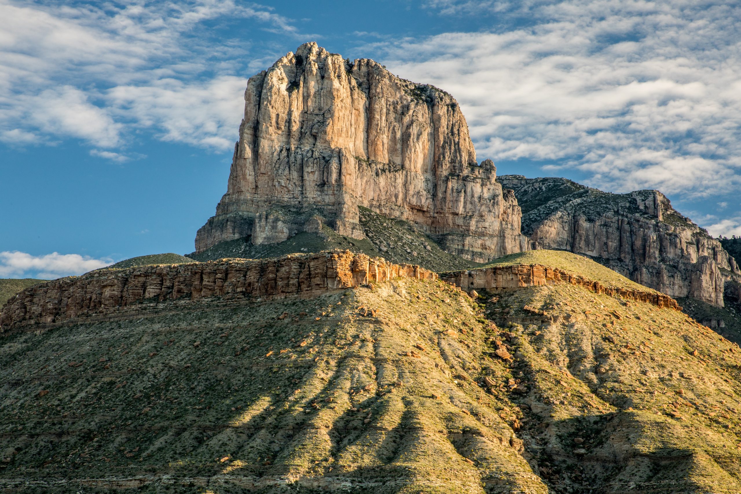
El Capitan/Salt Basin Overlook Trails
Difficulty: Moderate
Total Distance: 11.3
Time to Complete: 6-8 hrs
Elevation Gain: 1,900 ft
One of El Capitan’s best views is seen from the combination of the El Capitan and Salt Basin Overlook Trails. The vistas these two trails provide are probably the most wide-open of the Guadalupe Mountains National Park.
The Salt Basin Overlook Trail is an offshoot loop accessed from El Capitan Trail, giving you a few more miles of fun than simply taking El Capitan alone.
Here, the trails leave behind large plants and trees for high altitude windswept flowers and grass as it rounds the mountains.

Frijole/Foothills Trails
Difficulty: Moderate
Total Distance: 4.5 miles
Time to Complete: 4-6 hrs
Elevation Gain: 800 ft
One of the least traveled of the park’s trails; this hike will give you hours of solitude. It is also great for beginners as the difficulty level is much less with its 800 ft in elevation gain, but long enough to give you a few hours of trail time.
A walk through large builders and small trees is mixed with a variety of open views of the surrounding mountains and valleys.
For an even longer walk, join the Smith Spring Trail that connects at the Frijole Ranch Trailhead at its opposite end.

McKittrick Canyon Trailhead Hiking Trails in Guadalupe Mountains
Driving Directions: From Van Horn, Tx, take Hwy. 54N for 55 miles. Slight right onto US-180 E/US-62 E for 16.5 miles. Turn left onto McKittrick Rd, go 4.3 miles. From El Paso, TX, Take US-180 E/US-62 E to McKittrick Rd. 103 miles. Turn left onto McKittrick Rd. for 4.3 miles.
McKittrick Canyon Trail
Difficulty: Moderate
Total Distance: 20 miles
Time to Complete: 8-10 hrs
Elevation Gain: 4,400 ft
One of the most popular hiking trails in Guadalupe Mountains National Park is the Mckittrick Canyon Trail. It also has the most variety of things to see along your hike.
Walking along this trail, you will find the only permanent water source in the park, as all other streams are seasonal.
If you are a lover of trees, the Mckittrick Canyon Trail is made for you. Varieties found here are juniper, pine, maple, and madrone. A hike in the fall finds magnificent contrasts of colors before the trees begin to shed their leaves.
Don’t forget to stop and check out Pratt Lodge, Grotto picnic area, and Hunter Cabin for a look at history and a quick rest. The 20 miles of trails are available if you want to continue past each sightseeing area. For those who want a shorter hike, you can stop anywhere along the path and head back to the trailhead.

Permian Reef Trail
Difficulty: Difficult
Total Distance: 9 miles
Time to Complete: 4-5 hrs
Elevation Gain: 2,400 ft
Fossils and crystalline structures make the Permian Reef Trail’s difficult climb a geologist’s dream hike. Years of erosion have exposed many of these ancient finds to hikers along the trail.
Those who survive the steep and long ascent are rewarded with magnificent trees atop the plateau.
You’ll also have a chance to straddle the Texas and New Mexico border along your way before descending back down the trail.

Dog Canyon Trailhead Guadalupe Mountain NP Hikes
Driving Directions: From Van Horn, TX, take Hwy. 54N for 55 miles. Slight right onto US-180 E/US-62 E for 53.5 miles. Turn left onto Dark Canyon Rd for 22.6 miles. Turn left onto NM-137 S for 34.8 miles. Continue onto Dog Canyon Rd for .4 miles. From El Paso, TX, Follow US-54 E 77 miles to Dog Canyon Rd. Turn right and go 4.1 miles.
Indian Meadow Nature Trail
Difficulty: Easy
Total Distance: .6 miles
Time to Complete: 45 min-1 hr
Elevation Gain: 85 ft
A great family trail, this short hike is perfect for everyone in your group. The trail circles around its namesake, Indian Meadow, a place of calm breezes across the desert grass.
Surrounding the meadow are the Guadalupe Mountains, making for great scenery and a perfect place to take family pictures.
Go for an evening stroll at the end of the day for a relaxing walk in nature.

Lost Peak
Difficulty: Moderate
Total Distance: 6.5 miles
Time to Complete: 5-6 hrs
Elevation Gain: 1,540 ft
The hike to Lost Peak can be one of the park’s windiest hikes adding to the difficulty level. In cooler months, make sure to layer to protect you from the cold winds.
You will find more greenery during the hike than you may expect as trees line the surrounding steep hillsides as you enter the canyon.
After ascending, rocky hilltops await for an obstacle course of stones under your feet to make your way through.
If you want to add some distance and experience another one of the best hikes in Guadalupe Mountains National Park, McKittrick Ridge Trail connects along the route.
